


BLACK HEAD INTEGRAL

jeanmarcMasson
User GUIDE
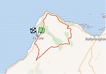

Length
24 km

Max alt
297 m

Uphill gradient
617 m
Km-Effort
32 km

Min alt
14 m

Downhill gradient
617 m
Boucle
Yes
Creation date :
2024-05-28 14:20:44.843
Updated on :
2024-05-28 14:23:49.008
7h23
Difficulty : Very difficult

FREE GPS app for hiking
 SityTrail
IGN / Geographical institutes
SityTrail Plus
The world is yours!
About
Trail Walking of 24 km to be discovered at Unknown, County Clare, West Clare Municipal District. This trail is proposed by jeanmarcMasson.
Positioning
Country:
Ireland
Region :
Unknown
Department/Province :
County Clare
Municipality :
West Clare Municipal District
Location:
Gleninagh
Start:(Dec)
Start:(UTM)
480895 ; 5885435 (29U) N.
Comments